Wanna be in pictures? Are you a professional photographer???
El Mirage Dry Lake is a famous location for desert scenes and western movies. Rock videos, automobile commercials... they all come here from around the world.
Since this is publicly owned land there is a permit required for professional imagery of any kind, photos or videos. The land belongs to the American people and the fees go to maintain the beauty and landscape that is being captured.
Here's the Film Permit <<< click for PDF
Will write more on this topic later. If you plan to shoot for any length of time an RV can be a real blessing. Restrooms are really basic, no running water. The air temps get down into the 50's this time of year but standing in the sun can feel like a heatwave. Wind and dust happen most days. Mornings are usually pretty calm but that changes quickly as the sun heats the lake bed and thermals start rising.
Wednesday, October 30, 2013
Tuesday, October 29, 2013

Monday, Wednesday and Friday mornings, unless windy, Frank and other Radio Control (RC) pilots take to the air over El Mirage Dry Lake with their stunt planes, sail planes and bombers! Bring coffee, a lawn chair and enjoy the show!
More photos at THIS LINK <<<
Monday, October 28, 2013

~~~~~~~~~~~~~~~~~~
01/10/51 B-50 Bomber Struck A Mountain Peak North Of EI Mirage Dry Lake, Near Victorville.
~~~~~~~~~~~~~~~~~~
04/18/42 Two instructors, 1st Lt. Albert Benton and 2nd Lt Curtis Elmer, from Victorville AAF, were killed when their BT15 crashed and burned near El Mirage lake.
~~~~~~~~~~~~~~~~~
\
\Reg #Accident dateAircraft typeNearest cityDetail pageMap page
N56078September 20, 2010Cosmos Phase IiEl Mirage, CASee details pageSee on map
N42KBOctober 19, 2001Brock Thorp T-18El Mirage, CASee details pageSee on map
N3593SOctober 18, 1964Cessna 172Rancho Mirage, CASee details pageSee on map
N4663AOctober 06, 1992Swich IiEl Mirage, CASee details pageSee on map
N4606VAugust 29, 1965Schweizer TG3AEl Mirage, CASee details pageSee on map
Sunday, October 27, 2013
Various Shoots
The El Mirage Dry Lake Bed location in the Mojave desert in San Bernardino County, east of Los Angeles, California, was used for filming the surface ofLambda Paz in the Star Trek: The Next Generation fourth season episode "Final Mission" in 1990. In 1994 it was also used to portray the surface of theOcampa homeworld in the Star Trek: Voyager pilot episode "Caretaker". In2002 the production used the midway between the El Mirage Dry Lake Bed and the Edwards Air Force Base to shoot the scenes on the Kolarus III surface inStar Trek Nemesis.
The location was also used for several other film and television projects including the science fiction film The Adventures of Buckaroo Banzai Across the 8th Dimension (1984), action film Lethal Weapon(1987), the science fiction sequel Terminator 2: Judgment Day (1991), the western comedyMaverick (1994), an the comedy remakeHerbie: Fully Loaded (2005). The El Mirage Dry Lake Bed can also be seen in the opening sequence of the television series Knight Rider(1982-1987).
Several musicians also filmed their music videos on this location such asShania Twain with "That Don't Impress Me Much", Josh Groban with "You Are Loved", and Metallica with "I Disappear".
I wish I could post this article in its entirety.
http://www.hotrod.com/feature_stories/hrdp_1210_southern_california_timing_association_inside_el_mirage_dry_lake/
Read more: http://www.hotrod.com/feature_stories/hrdp_1210_southern_california_timing_association_inside_el_mirage_dry_lake/#ixzz2izC5utJh
http://www.hotrod.com/feature_stories/hrdp_1210_southern_california_timing_association_inside_el_mirage_dry_lake/
These days, the Bonneville Salt Flats get all the glory; we've often seen them called the birthplace of hot rodding. Wrong. While Bonneville is immensely spectacular and significant, and has been raced upon for a 100 years, hot rodders as we know them didn't set tread on the salt until the first Bonneville Nationals in 1949. Before then--back to at least the early '30s--hot rodding and top-speed racing happened on Southern California's dry lakebeds such as Harper, Rosamond and Muroc (now within Edwards Air Force Base), and El Mirage.
Base), and El Mirage.
While the first race organized by the Southern California Timing Association was held in 1938 at Muroc, the SCTA has most often used El Mirage, and has done so continuously from 1938 until now, excluding during WWII. The SCTA currently hosts six events a year there, in May, June, July, September, October, and November. The scene shown in the photo is of the May '12 opening event with about 100 entries. The season-opening and closing events are full weekends, the others are just Sundays.
The race format at El Mirage is much like that of Bonneville: From a standing start, accelerate to your car's highest possible speed before the timing lights. At El Mirage, the track is 1.3 miles long with a 132-foot timing trap at the end. Unlike at Bonneville, where records are set based on an average of one record-qualifying run and one backup run, a single pass at El Mirage can net you a land-speed record if your run is at least 0.001 mph faster than the existing record. Also unlike at Bonneville, there are record minimums at El Mirage; for example, if there's an "open class" (one with no record because no one has ever run in the class), there will be a mph established as the minimum speed required to achieve a record in the class. At Bonneville, you can set a record in an open class at any speed at all. The reason for the difference is that El Mirage offers a season-long championship that's partially based on points earned by breaking records, and by how drastically you exceed the existing record. Without minimums, there could be too much sandbagging. Not that it doesn't happen, anyway.
highest possible speed before the timing lights. At El Mirage, the track is 1.3 miles long with a 132-foot timing trap at the end. Unlike at Bonneville, where records are set based on an average of one record-qualifying run and one backup run, a single pass at El Mirage can net you a land-speed record if your run is at least 0.001 mph faster than the existing record. Also unlike at Bonneville, there are record minimums at El Mirage; for example, if there's an "open class" (one with no record because no one has ever run in the class), there will be a mph established as the minimum speed required to achieve a record in the class. At Bonneville, you can set a record in an open class at any speed at all. The reason for the difference is that El Mirage offers a season-long championship that's partially based on points earned by breaking records, and by how drastically you exceed the existing record. Without minimums, there could be too much sandbagging. Not that it doesn't happen, anyway.
The most significant chasm between Bonneville and El Mirage is the surface itself: Bonneville is salt, El Mirage is silt--hopefully hard-packed silt, but often not. Those who've run the Salt Flats and had traction problems haven't even begun to suffer. El Mirage racing can be like running across a plowed field. Worse, the shorter distance makes it more critical to put the power down earlier; it's more of a drag race. Between the challenges and the history of the place, we consider getting into the El Mirage 200 MPH Club a much more significant accomplishment than entering the Bonneville 200 MPH Club. Really.
The fastest record on the dirt is 312.100 mph in the Leggitt-Mirage C/Blown Fuel Lakester. In all, there are six records exceeding 300 mph, five of which involved Les Leggitt engines. Twelve men have walked on the moon. Draw your own conclusions.
Read more: http://www.hotrod.com/feature_stories/hrdp_1210_southern_california_timing_association_inside_el_mirage_dry_lake/#ixzz2izC5utJh
Thursday, October 24, 2013
BLM staff is meeting this week with Great Outdoors Consultants regarding the design for the ATV training area, being constructed south of the Visitor Center. The area is currently used for ASI certification of BLM and other employees and volunteers and will be developed into a beginner/intermediate youth training course.


Here's the view today looking west toward the entrance road from the highest point of the training area. See "South Hill" in the photo above.

The project team, at this point consists of the two consultants from Great Outdoors Consultants, Ranger Rose Beardshear, BLM Maintenance employees and ACE consultant James Lynn.

Left to right: James Keeler GOC, James Lynn ACE,Mike Trost, Danny Pando and front Vicki Salazar BLM, Interpretive Ranger Rose Beardshear, Drew Stoll GOC.
Later this week the group will see suggested design for skills training, practice areas and parental observation posts in the ATV training area.
Newspaper articles on El Mirage history.
The history of El Mirage (Grey Mountain until 1917) has been captured in numerous newspaper articles over the years. The articles on file began in 1913 as published in a paper referred to as the News-Herald. Many are in a column titled Mirage Valley which reported social, construction and activities each day.
Advertisements and commentary over the years refer to land sales booms as early as 1917 and continuing into the '70s. ie: "...Nevada County DA Harold Berlinger stating, “We now have enough lots in Nevada County for 72 years… But they are houseless.” Discussions took place in 1976.


Advertisements and commentary over the years refer to land sales booms as early as 1917 and continuing into the '70s. ie: "...Nevada County DA Harold Berlinger stating, “We now have enough lots in Nevada County for 72 years… But they are houseless.” Discussions took place in 1976.


More entertaining and relative to the land speed racing are articles about who bought a new car and what records are being set:


Along the lines of the actual history of the area are the references to early settlers, explorers and the post office for the Community of Grey Mountain, which was renamed El Mirage in 1917. The post office closed in 1927 for lack of activity.


Wednesday, October 23, 2013
Scorpions are nocturnal, predatory animals that feed on a variety of insects, spiders, centipedes, and other scorpions. Large scorpions occasionally feed on vertebrates such as small lizards, snakes, and mice. Most scorpions live in warm, dry climates, and many of the species found in North America occur in Arizona, adjacent areas of California, and parts of New Mexico. Of the 70 or so species found in North America, only one, the bark scorpion, Centruroides exilicauda (formerly C. sculpturatus), is considered dangerous to people.

IDENTIFICATION
Scorpions are easily distinguished by their crablike appearance, pair of pincers, four pairs of legs, and long, segmented tail ending with an enlarged segment bearing a stinger. Although they have two eyes in the center of the head and usually two to five more along the margin on each side, they don't see well and depend on touch. When running, they hold their pincers outstretched, and the posterior end of the abdomen is usually curved upward. Scorpions that hide under stones and other objects during the day tend to carry their stinger to one side, whereas burrowing scorpions hold their stinger up over their backs.
Monday, October 21, 2013
When in Barstow, visit the BLM Discovery Center! Learn about desert life with live exhibits of several animals natural to the area.


Desert Tortoise
The desert tortoises (Gopherus agassizii and Gopherus morafkai) are species of tortoise native to the Mojave desert and Sonoran desert of the southwestern United States and northwestern Mexico and the Sinaloan thornscrub of northwestern Mexico.[3] Gopherus agassizii is distributed in western Arizona, southeastern California, southern Nevada, and southwestern Utah.[3] The species nameagassizii is in honor of Swiss-American zoologist Jean Louis Rodolphe Agassiz. Recently, on the basis of DNA, geographic, and behavioral differences between desert tortoises east and west of the Colorado River, it was decided that two species of desert tortoises exist: the Agassiz's desert tortoise (Gopherus agassizii) and Morafka's desert tortoise (Gopherus morafkai).[4] Gopherus morafkaioccurs east of the Colorado River in Arizona as well as in the states of Sonora, Sinaloa, Mexico. This species may be a composite of two species.
The desert tortoises live approximately 30 to 50 years; they grow slowly and generally have low reproductive rates.
How does the Desert Tortoise ADAPT to the desert environment?
They spend most of time in burrows, rock shelters, and pallets to regulate body temperature and reduce water loss. They are most active after seasonal rains and are inactive during most of the year. This inactivity helps reducing water loss during hot periods, whereas winter hibernation facilitates survival during freezing temperatures and low food availability. Desert tortoises can tolerate water, salt, and energy imbalances on a daily basis, which increases their lifespan.[5] <<< from Wikopedia

Western Pond Turtle
Actinemys marmorata
Actinemys marmorata
Learn more about the Western Pond Turtle: Click Here <<<
Friday, October 18, 2013
Now for a .EDU moment while I figure out what some of these terms are:
The surface of the dry lake is referred to a Alluvial.
The surface of the dry lake is referred to a Alluvial.
From Wikipedia, the free encyclopedia
"Alluvial" redirects here. For the American racehorse, see Alluvial (horse). For the type of flow diagram, see Alluvial diagram.


Alluvium (from the Latin, alluvius, from alluere, "to wash against") is loose, unconsolidated (not cemented together into a solid rock)soil or sediments, which has been eroded, reshaped by water in some form, and redeposited in a non-marine setting.[1][2] Alluvium is typically made up of a variety of materials, including fine particles of silt and clay and larger particles of sand and gravel. When this loose alluvial material is deposited or cemented into a lithological unit, or lithified, it would be called an alluvial deposit.
In the case here of El Mirage the surface of the dry lake is a clay that creates the driving surface, amazingly flat without bumps or surface disturbances that make it ideal for high speed vehicle test drives.
Playa
From Wikipedia, the free encyclopedia
| Look up playa or playas in Wiktionary, the free dictionary. |
Playa (plural playas) may refer to:
Contents
[hide]Landforms[edit]
- Sink (geography), also known as an alkali flat or sabkha, a desert basin with no outlet which periodically fills with water to form a temporary lake
- Dry lake, commonly called a playa in the southwest US and Mexico
- Playa is the Spanish language word for beach
Thursday, October 17, 2013
Why is it cold here??? I decided to look up the definition(s) of High Desert on Wickopedia:

High desert
High desert refers to inland high-elevation (commonly 2000 feet [610m] or more above sea level) deserts of the American West, the Middle East, and other parts of the world. Examples of high deserts in North America include the Great Basin Desert and the Mojave Desert.
Places[edit]
- High Desert, Albuquerque, New Mexico, a development in Albuquerque, New Mexico, United States
- High Desert (California), an area encompassing north Los Angeles County, north San Bernardino County, and Kern County, California, in the United States
- High Desert (Oregon), an area in Eastern Oregon, United States
- Colorado Plateau, a high desert area in the United States of 337,000 km2 (130,000 mi2) within western Colorado, northwestern New Mexico, southern and eastern Utah, and northern Arizona.
Other[edit]
- The High Desert Museum in Bend, Oregon, United States
- High Desert State Prison (Nevada) in Indian Springs, Nevada
- High Desert State Prison (California) in Susanville, California
Here's what I find about the elevation of the El Mirage Dry Lake:
El Mirage Lake
Surface elevation: 2,838' (865 m)
Length: 6.214 miles (10 km)
Width: 1.864 miles (3 km)
El Mirage Lakebed experiences a desert climate, with cool winters and hot summers. Due to the lakebed's aridity and altitude, theDiurnal temperature variation is substantial. Though summer days can be very hot, summer nighttime temperatures are cool. The lakebed receives an occasional dusting of snow in the winter months, however, snowfall usually melts within 24 hours.

Making tracks...
Took a morning hike below the east ridge of the Shadow Mountains here at El Mirage Dry Lake. In the crusty sand picked up several tracks of critters from their recent walks.


This looks like a coyote track. The business card, for comparison, is 3 1/2 inches tall.

Not sure what caused these channels to be formed in a rock, but I found it interesting. The rock is about 4" on each side.
Two videos to follow shortly.
Wednesday, October 16, 2013


Saturday, October 12, 2013

Thursday, October 10, 2013

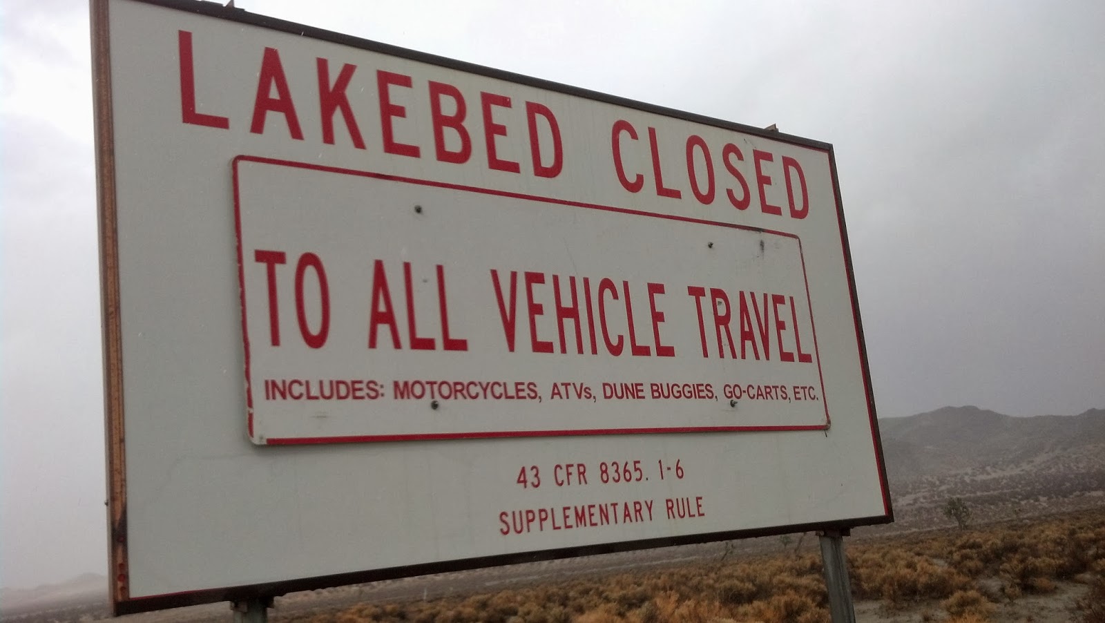

Rain settled in for an hour or so yesterday afternoon. Didn't seem like a lot (in mid-west terms) but water accumulated quickly on the surface and James tells me that the lake bed surface will be closed to vehicles for about one week before it dries.
Interesting to live near a lake with no fish and no water. When there is water the lake is closed... Where else can the word "lake" be an oxymoron?
Will hike around this morning and see if the sand turns up any fresh animal prints. Should be interesting.
Here's my art photo from the other day... great color matching by a graffiti artist.

Subscribe to:
Posts (Atom)